
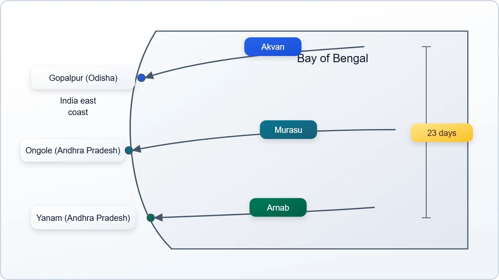
Three named cyclones crossing the Bay of Bengal within twenty-three days is the kind of meteorological sequence that forces forecasters, disaster managers and coastal communities to recalibrate their assumptions about the post-monsoon season. Cyclone Arnab made landfall near Yanam on the Andhra Pradesh coast on 28 October 2026, Cyclone Murasu struck near Ongole on 3 November, and Cyclone Akvan formed on 16 November before coming ashore near Gopalpur in Odisha on the morning of 20 November. Each storm followed its own track and intensity curve, yet the compressed rhythm of their arrival is what gives the season its analytical weight.
What makes the sequence instructive is that it did not emerge from a single freak atmospheric event. The Bay of Bengal operates on two recognised cyclone windows, April to May and October to December, and the transition out of the southwest monsoon is precisely when the basin becomes most receptive. During the monsoon itself, winds blowing in different directions at different heights shear developing systems apart before they can consolidate. Once the monsoon withdraws, that vertical wind shear weakens while sea surface temperatures remain elevated, and the thermodynamic and dynamic ingredients required for cyclogenesis fall into alignment.
Historical context tempers the alarm without dismissing it. Three cyclones in three weeks is unusual but not unique, and the longer record shows a basin that has been generating post-monsoon storms with growing frequency. Between 1982 and 2022, the post-monsoon period averaged roughly 1.8 cyclones a year, and that average has climbed since 2001. Understanding why requires attention to ocean heat content, monsoon withdrawal timing, Madden-Julian Oscillation phases and the sheer geography of a shallow, landlocked basin that heats rapidly and discharges moisture efficiently.
On This Page
TL;DR Three cyclones — Arnab, Murasu and Akvan — formed over the Bay of Bengal within twenty-three days in late 2026, making landfall near Yanam, Ongole and Gopalpur respectively. The clustering reflects the classic post-monsoon window, when weakening vertical wind shear and a still-warm sea surface remove the brakes on cyclogenesis. Three storms in three weeks is unusual but not unprecedented; the post-monsoon average of about 1.8 cyclones per year between 1982 and 2022 has risen since 2001, pointing to a basin whose seasonal behaviour is shifting in ways that matter for forecasting, coastal planning and disaster readiness.
The Anatomy of Bay of Bengal Cyclogenesis
Cyclone formation in the Bay of Bengal is never a matter of a single favourable variable. Forecasters look for a pre-existing atmospheric disturbance, abundant moisture in the lower and middle troposphere, and winds that cooperate rather than compete across different altitudes. When these three conditions converge over warm water, a low-pressure area can organise into a depression, then a deep depression, then a cyclonic storm with a defined eye and closed circulation. The Bay supplies the moisture generously; the difficulty lies in sustaining the wind structure long enough for the system to mature.
The basin's geography amplifies both its fertility and its danger. It is comparatively shallow and enclosed by land on three sides, which allows surface waters to warm quickly and hold heat close to the coast. River discharge from the Ganges, Brahmaputra and Mahanadi systems delivers enormous freshwater volumes that can create stable surface layers, while also influencing salinity gradients that affect how heat is mixed downward. The result is a marine environment capable of fuelling rapid intensification, sometimes within hours, which compresses the warning window available to coastal districts.
The Three Essential Ingredients
Warm sea surface temperatures above roughly 26.5 degrees Celsius provide the thermal engine, but temperature alone is insufficient. The system also requires sufficient ocean heat content at depth so that mixing does not immediately cool the surface and starve the storm of energy. Equally important is low vertical wind shear, meaning winds at different heights must blow at similar speeds and directions; strong shear tilts and tears the convective core. Finally, a triggering disturbance, often a remnant low, an easterly wave or a cross-equatorial flow, supplies the initial spin and convergence that lets the process begin.
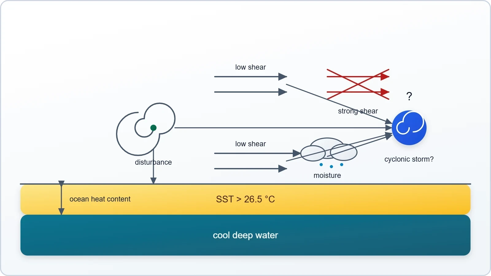
Moisture availability completes the quartet. The Bay of Bengal's humidity during the post-monsoon window is exceptionally high, and mid-level dry air intrusions are less common than in some other basins. When all these factors align, the limiting factor becomes time: how long the system can remain over open water before landfall interrupts its supply of heat and moisture. The proximity of the Indian coastline means many Bay systems intensify quickly but have only a few days to do so, which is why forecast uncertainty remains a persistent operational challenge.
Why the Post-Monsoon Window Opens
During the southwest monsoon, the atmosphere over the Bay is characterised by strong vertical wind shear. Winds at upper levels blow in a markedly different direction from those near the surface, and this differential shears apart incipient vortices before they can develop a warm core. The monsoon's withdrawal changes the picture fundamentally. As the large-scale circulation relaxes, upper-level winds weaken and align more closely with low-level flow, reducing shear to values that permit vertical stacking of the storm's circulation. Simultaneously, the sea retains the heat accumulated through the summer months.
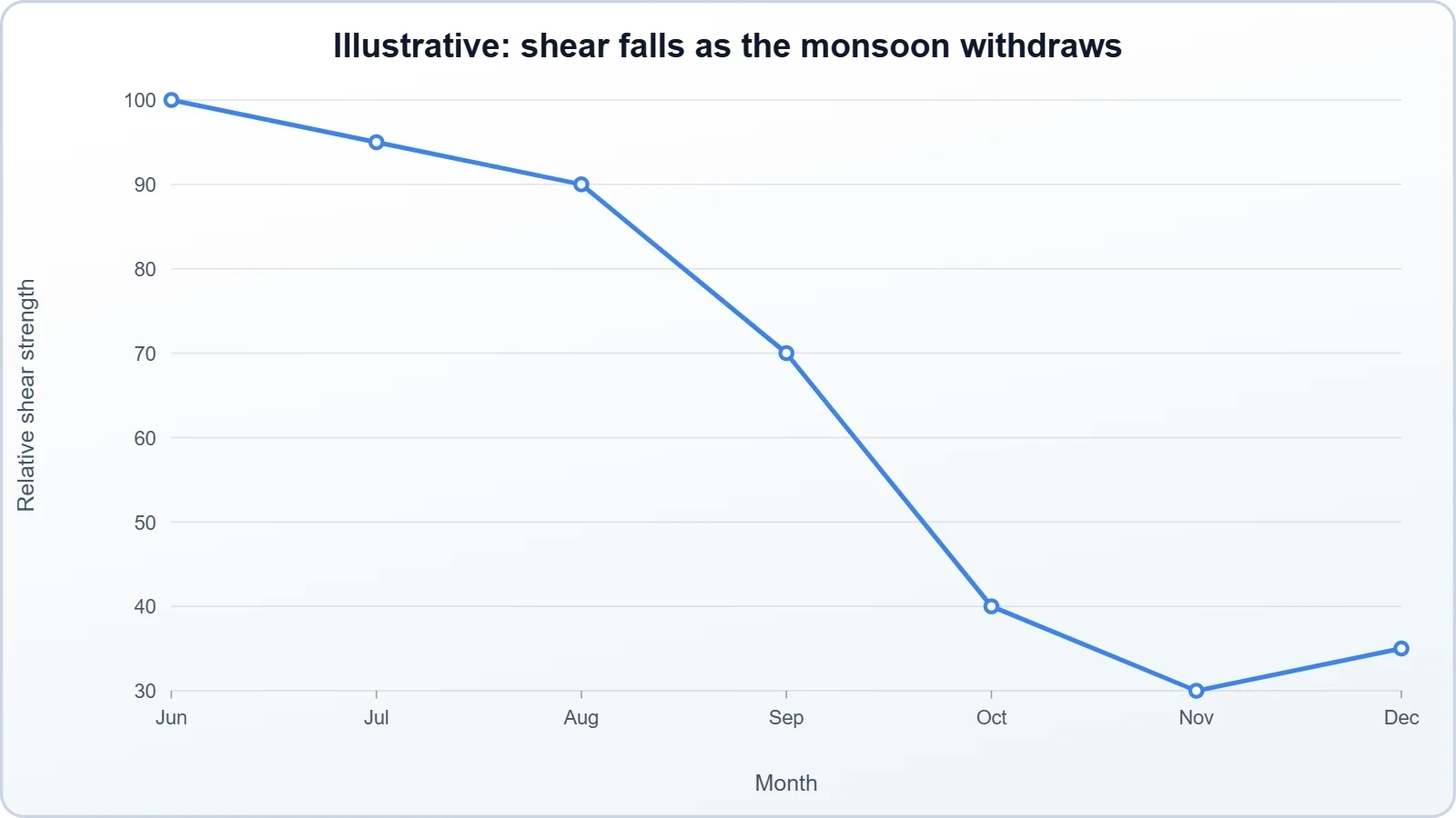
This transition is not instantaneous, and the timing of monsoon withdrawal varies year to year, which introduces significant interannual variability into the post-monsoon cyclone season. A late withdrawal compresses the favourable window; an early withdrawal extends it. The Madden-Julian Oscillation, an eastward-propagating pulse of enhanced and suppressed convection, can further modulate activity on weekly timescales, creating active and quiet phases within the broader seasonal envelope. The 2026 clustering likely reflects an alignment of these large-scale factors rather than a single cause.
Reading the Historical Record
Climatological averages are the natural first reference point, and here they are revealing. Between 1982 and 2022, the post-monsoon period produced an average of about 1.8 cyclones per year over the Bay of Bengal. That figure is not a ceiling; it is a mean around which individual seasons scatter widely, with some years producing none and others producing several. The 2026 season's three storms in three weeks sits at the upper end of that distribution, which is why meteorologists describe it as unusual but not unique rather than unprecedented.
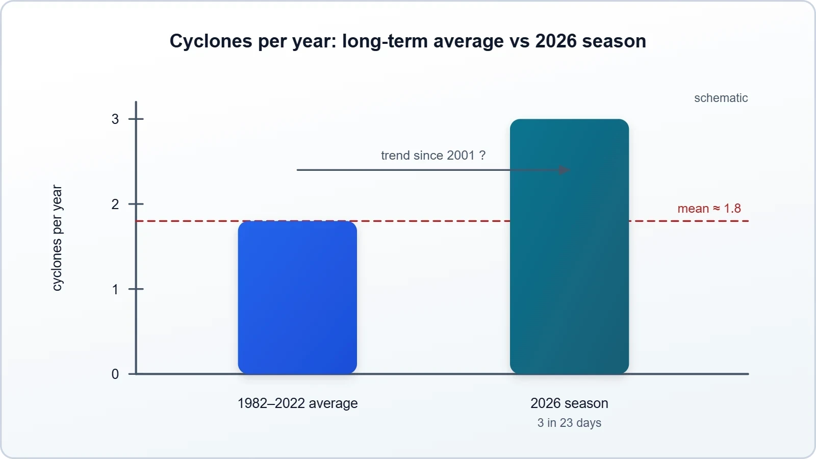
The more consequential observation concerns the trend. The post-monsoon average has risen since 2001, suggesting that the basin's late-year activity is not stationary. Several mechanisms could contribute: warmer sea surface temperatures extending the favourable window, changes in monsoon withdrawal timing, and shifts in large-scale circulation that alter wind shear patterns. Attribution is difficult because the sample of seasons is short and natural variability is substantial, but the direction of the signal is consistent enough to warrant attention from both researchers and coastal planners.
What the Averages Conceal
A mean of 1.8 cyclones per year tells us little about the distribution of risk. Cyclone damage is driven by the tail of the distribution, by the occasional season that produces multiple intense systems in quick succession, and by the specific tracks those systems take. A season with three moderate storms making landfall in sparsely populated stretches may cause less harm than a single severe cyclone crossing a dense urban corridor. Frequency statistics are therefore a starting point for risk assessment, not a substitute for it.
There is also the question of rapid intensification. A storm that strengthens from a depression to a severe cyclone in under twenty-four hours compresses evacuation timelines and stresses forecasting confidence. The Bay of Bengal's warm, shallow waters and high moisture availability make it particularly conducive to such episodes. When multiple systems form in close succession, the operational burden compounds: forecasters, relief agencies and local administrations must manage overlapping warnings, resource deployments and recovery efforts without the usual interval for consolidation.
The Role of Ocean Heat Content
Sea surface temperature is the headline metric, but ocean heat content, the integrated thermal energy stored in the upper ocean, is often the better predictor of intensification potential. A storm churns the water beneath it, bringing cooler water to the surface; if the warm layer is deep, the storm's own mixing does not significantly weaken its energy supply. In the Bay of Bengal, ocean heat content varies considerably across space and time, influenced by river discharge, currents and the passage of previous systems.
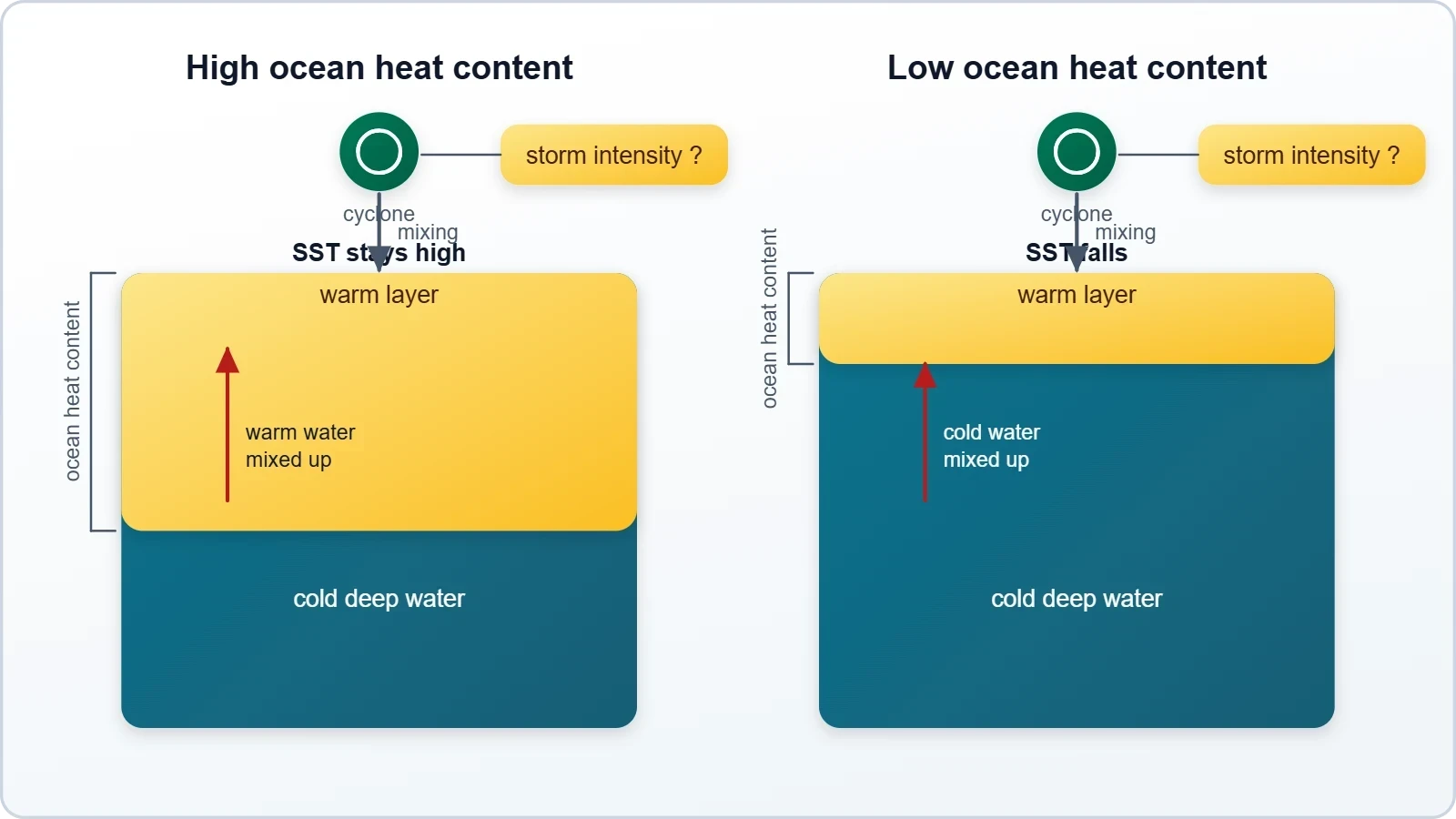
This matters for interpreting the 2026 sequence. Each successive cyclone can alter the thermal and salinity structure of the basin, potentially affecting the environment available to the next system. The interaction is not straightforward; a storm may cool surface waters along its track while mixing warmer water upward elsewhere. Understanding these feedbacks is an active area of research, and it bears directly on the question of whether clustered cyclone seasons are becoming more likely or whether 2026 represents a natural fluctuation within a slowly shifting baseline.
Why Clustering Matters More Than Counting
The distinction between a busy season and a clustered season is operationally significant. A season that produces three cyclones spread across October, November and December allows coastal administrations to reset between events: shelters can be restocked, roads repaired, power restored and personnel rotated. A season that compresses three landfalls into twenty-three days removes that recovery interval almost entirely. Damage assessments overlap with fresh warnings, and the same districts may be asked to absorb repeated shocks before the first round of reconstruction has begun.
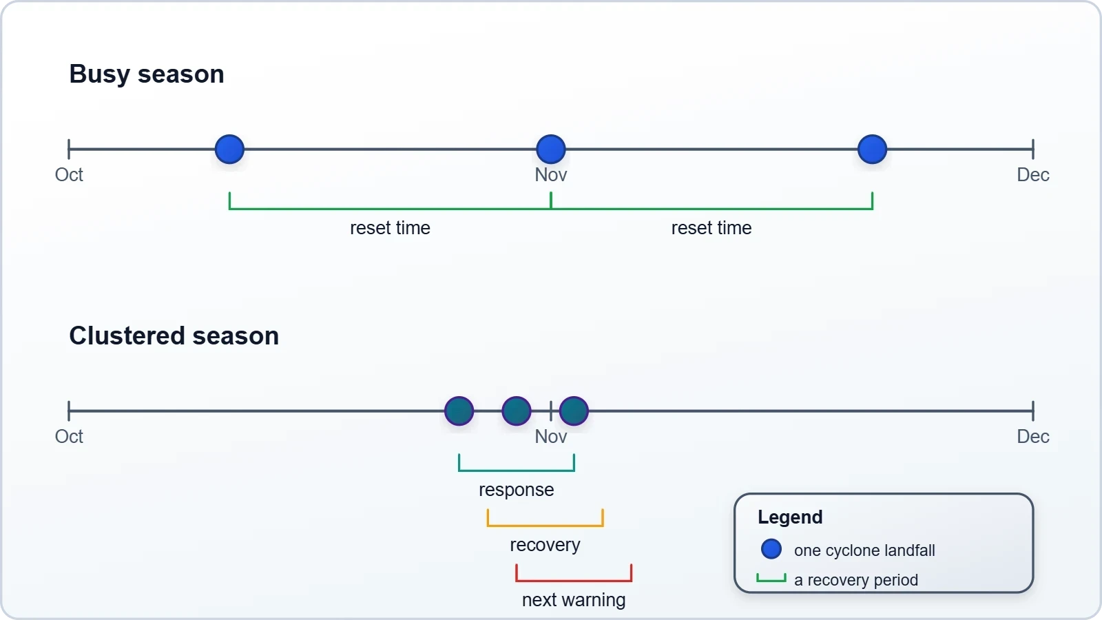
Clustering also complicates forecasting communication. When one storm is dissipating and another is forming, public attention fragments. Evacuation orders issued for a second system may be met with fatigue from communities still recovering from the first. The credibility of warnings depends on consistent, well-timed messaging, and back-to-back events strain the capacity of agencies to maintain that consistency. The 2026 sequence, with landfalls near Yanam, Ongole and Gopalpur in quick succession, illustrates how a modest count of storms can produce an outsized operational load.
Compounding Coastal Vulnerability
Coastal vulnerability is not static, and repeated landfalls interact with existing stresses. Storm surge from an early cyclone can erode dunes and damage embankments, leaving the coast more exposed to the next system. Saltwater intrusion into agricultural land and aquifers may persist long after winds subside, reducing the resilience of livelihoods that depend on freshwater. Infrastructure damaged but not fully repaired becomes a liability in the following event, and the cumulative effect can exceed the sum of individual impacts.
Population density along the Andhra Pradesh and Odisha coasts amplifies these dynamics. Aquaculture, fishing and agriculture sustain millions of people in low-lying areas, and each cyclone disrupts these sectors simultaneously. Recovery timelines for ponds, nets, boats and crops are measured in months, not days. When a second storm arrives before recovery is complete, households may be forced to liquidate assets or take on debt, converting a meteorological event into a prolonged economic setback that outlasts the news cycle.
The Forecast Challenge
Forecasting a single cyclone is difficult; forecasting a sequence is harder still because each system modifies the environment for the next. Track and intensity models must account for the ocean's thermal response, the atmospheric moisture field and the large-scale circulation, all of which evolve as storms pass. Ensemble forecasting helps by generating a range of plausible outcomes, but the spread between members can be wide, particularly for intensity, which is the variable that most directly determines casualties and damage.
Improved satellite coverage, Doppler radar networks and ocean buoys have narrowed some of these uncertainties, and numerical weather prediction has advanced considerably. Yet rapid intensification remains a stubborn forecasting problem, and the Bay of Bengal's shallow, warm waters make it a frequent setting for such episodes. The practical implication is that coastal communities need warning systems that assume uncertainty rather than waiting for certainty, and evacuation protocols that can be activated on probabilistic rather than deterministic grounds.
- 01
- 02
- 03
- 04
The Larger Climate Context
Any discussion of a single season must be placed against the backdrop of a warming ocean. The Bay of Bengal has been absorbing increasing amounts of heat, and warmer water extends the depth of the layer available to fuel storms. This does not automatically translate into more cyclones, because other factors such as wind shear and moisture distribution also matter, but it does raise the ceiling on intensity. The observed rise in the post-monsoon average since 2001 is consistent with a basin whose thermal environment is becoming more conducive to late-year activity.
Attribution science has made progress in linking individual events to climate change, but clustered sequences are harder to attribute than single storms. The relevant question is not whether climate change caused the 2026 sequence but whether the conditions that made it possible are becoming more common. On present evidence, the answer appears to be a qualified yes: warmer seas, shifting monsoon timing and altered circulation patterns are all consistent with a lengthening or intensifying post-monsoon window, even as natural variability continues to dominate individual seasons.
Monsoon Withdrawal and Timing
The timing of the southwest monsoon's withdrawal is a critical variable. An early withdrawal exposes the Bay to favourable cyclone conditions sooner, potentially extending the season. A late withdrawal compresses the window and may push activity later into November and December. The withdrawal is itself influenced by large-scale circulation patterns that are sensitive to temperature gradients between land and sea, which means that climate change can affect cyclone seasons indirectly through its influence on monsoon timing.
This indirect pathway is often overlooked in public discussion, which tends to focus on sea surface temperatures alone. In practice, the interaction between monsoon dynamics and cyclone formation is what determines whether a given year produces a cluster or a quiet season. The 2026 sequence, arriving after a monsoon withdrawal that left the Bay warm and shear conditions relaxed, fits this framework. It is a reminder that cyclone risk is a function of atmospheric circulation as much as ocean heat.
Implications for Adaptation
Adaptation to clustered cyclone risk requires more than stronger embankments. It requires institutions capable of managing overlapping events, supply chains that can deliver relief to multiple districts simultaneously, and communication strategies that sustain public trust across repeated warnings. Early warning systems have improved markedly in India, and evacuation rates during recent cyclones have been encouraging, but the margin for error narrows when events arrive in quick succession and resources are already committed.
Longer-term planning must also account for the possibility that the post-monsoon window becomes more active on average. Coastal zoning, building codes, mangrove restoration and aquifer management all interact with cyclone risk, and their benefits compound over time. The cost of preparing for a more active basin is real, but it is modest compared with the cost of repeated, poorly managed disasters. The 2026 sequence is best read not as a warning of imminent catastrophe but as a prompt to strengthen systems that will be tested again.
We Also Published
What the 2026 Sequence Teaches
The most useful lesson from the 2026 sequence is that the Bay of Bengal's post-monsoon behaviour is best understood as a system of interacting variables rather than a fixed calendar. The two recognised seasons, April to May and October to December, describe the climatological envelope, but the actual timing and intensity of activity within that envelope depend on monsoon withdrawal, wind shear, ocean heat content and large-scale circulation. When these align, the basin can produce multiple storms in rapid succession, as it did with Arnab, Murasu and Akvan.
A second lesson concerns the difference between frequency and impact. Three cyclones in twenty-three days is a notable statistic, but the harm they cause depends on where they land, how strong they are and what they hit. The landfalls near Yanam, Ongole and Gopalpur placed the storms along a stretch of coast with substantial aquaculture, agriculture and fishing livelihoods. The cumulative disruption to these sectors, and the speed of recovery between events, may matter more than the raw count of storms.
For Forecasters and Agencies
Operational agencies should treat clustered seasons as a distinct planning scenario rather than an amplified version of a normal season. That means pre-positioning relief supplies across multiple districts, maintaining reserve capacity for personnel and equipment, and designing communication strategies that remain effective when warnings overlap. The assumption that there will be time to reset between events is precisely what a clustered season invalidates, and planning that does not account for this will be caught short.
Forecasters also face a scientific challenge: improving intensity prediction, particularly for rapid intensification, and understanding how one storm modifies the environment for the next. Investment in ocean observing systems, including buoys and gliders that measure subsurface heat content, pays dividends here. So does the continued development of ensemble methods that communicate uncertainty honestly rather than projecting false confidence. The goal is not perfect prediction but decision-relevant prediction that allows authorities to act before certainty arrives.
For Coastal Communities
Communities along the Bay of Bengal coast have generations of experience with cyclones, and that experience is an asset. Local knowledge of evacuation routes, shelter locations and vulnerable neighbours complements formal warning systems. What clustered seasons test is stamina: the ability to respond to a second and third warning while still recovering from the first. Strengthening community institutions, from panchayats to fishing cooperatives, helps distribute the burden and maintain collective capacity when formal systems are stretched.
Practical measures matter as much as institutional ones. Secure storage for documents and valuables, diversified income sources, and familiarity with early warning messaging all reduce vulnerability. So does attention to the needs of elderly residents, people with disabilities and households without transport. These are not novel recommendations, but their importance rises when events arrive in quick succession and the margin for improvisation shrinks. Preparedness is cumulative, and seasons like 2026 reward communities that have built it over time.
Looking Ahead to Future Seasons
Projecting future post-monsoon activity requires humility about the limits of current models. The observed rise in the average since 2001 is a signal worth tracking, but it is embedded in substantial natural variability, and a few quiet seasons could flatten the apparent trend. What can be said with more confidence is that the physical ingredients for cyclogenesis, warm water, moisture and favourable winds, are not becoming scarcer. A basin that is warmer and more humid is, all else equal, more capable of producing intense storms.
The practical response is to build systems that perform well across a range of plausible futures rather than optimising for the recent past. That means investing in forecasting, observation, infrastructure and community capacity simultaneously, and treating each as complementary rather than substitutable. A perfect forecast is of limited use without evacuation routes, and a well-built embankment cannot compensate for a warning that arrives too late. Resilience is a portfolio, and the 2026 sequence is a reminder of why the portfolio matters.
Research Priorities
Several research directions stand out. Better understanding of air-sea interaction in shallow, freshwater-influenced basins would improve intensity prediction. So would higher-resolution ocean observations that capture subsurface heat content in the regions where storms intensify. On the atmospheric side, research into how monsoon withdrawal timing responds to warming, and how the Madden-Julian Oscillation modulates Bay activity, would sharpen seasonal outlooks. These are not abstract questions; they translate directly into the lead times available to coastal districts.
Attribution research also deserves attention. Distinguishing the contribution of climate change from natural variability in clustered sequences is methodologically demanding, but it informs how societies should weigh adaptation investments. If clustered seasons become more common, the case for stronger coastal infrastructure and more flexible disaster response grows. If they remain rare, the case for maintaining readiness without over-investing in low-probability scenarios is stronger. Either way, the analysis depends on a clearer understanding of the mechanisms at work.
A Balanced Reading
The 2026 sequence is neither a portent of imminent collapse nor a statistical curiosity to be dismissed. It sits within a historical range that includes other busy seasons, but it also reflects a basin whose underlying conditions are shifting. The responsible interpretation is to treat it as a data point that reinforces existing concerns about coastal vulnerability and the value of preparedness, while resisting the temptation to draw sweeping conclusions from a single season. Science advances by accumulating evidence, and this season adds to the record.
For readers following the Bay of Bengal's weather, the practical takeaway is straightforward. The post-monsoon window is real, the ingredients for cyclogenesis are well understood, and the historical average has been rising. Coastal communities, forecasters and policymakers should plan for the possibility of clustered events without assuming they will occur every year. That posture, alert but not alarmist, is the one most likely to produce good decisions under uncertainty, and it is the posture that the evidence from 2026 best supports.
From our network :
- CISA’s Ten-Advisory Wave: Why Generic Patching Fails in OT and How to Build Product-Specific PlaybooksCISA released ten ICS advisories in one week, exposing critical infrastructure risks. Generic patching fails in OT. Learn to build product-specific remediation playbooks.
- University Language Proficiency Exams: Why Institutional Tests Demand Different Preparation Than IELTS and TOEFLDiscover why university-specific language proficiency examinations differ fundamentally from IELTS and TOEFL, and learn strategic preparation approaches for institutional assessment success.
- The Hidden Cost of AI Convenience: Why Over-Permissioned Agents Are a Security Time BombDiscover why AI agents with excessive permissions create dangerous single points of failure, and learn how implementing least privilege principles can protect your organization from exploitation.
- Committed Mediterranean Precipitation Decline: Why Emissions Cuts Alone Cannot Restore Winter RainsNew NOAA research reveals that Mediterranean winter rains may decline irreversibly even with emissions cuts. Explore the science of committed climate change and regional impacts.
- Forbidden Matrix Patterns and Visible Lattice Points: A Geometric DictionaryExplore how multidimensional 0–1 matrices encode geometric truths, linking forbidden patterns to visible lattice points and hypergraph theory, with applications in combinatorics and computational geometry.
- How AI Agents Will Change the Way We Manage Personal FinancesExplore how AI agents are transforming personal finance through automated budgeting, bill payment, and investment management, while examining the critical security protocols and governance frameworks required for safe deployment.
- The Final Descent: How ESA Retired the Legendary Cluster Constellation After 24 Years of Space Weather ScienceAfter 24 years mapping Earth’s magnetosphere, ESA’s Cluster mission concluded with a precisely controlled reentry over the South Pacific. This analysis explores the scientific legacy, engineering decisions, and debris mitigation principles behind one of space exploration’s most responsible retirements.
- Mobile Learning and VR in English: What Global Evidence Reveals About Effective Language TechnologyA systematic review across 14 countries reveals which language-learning technologies genuinely work. Mobile learning, AI, and VR show measurable benefits when pedagogically integrated. This evidence-based guide helps educators and learners select technology that delivers real return on investment.
- Live Online English Classes for Kids: Do They Actually Reduce Anxiety?A ten-week study reveals that synchronous online English classes can significantly reduce child language anxiety while improving listening and reading skills. Discover what makes these programs effective and how parents can select the right one.
RESOURCES
- Resources will be updated soon.
- 01
- 02
- 03
- 04
- 05
- 06
- 07
- 08
0 Comments