
The equatorial Pacific is currently exhibiting one of the most anomalous thermal signatures observed since satellite monitoring began, and the implications extend well beyond the ocean surface. Subsurface waters in the eastern tropical Pacific are running as much as 18 degrees Fahrenheit above seasonal norms, a reservoir of heat that continues to migrate upward toward the air-sea interface. Michelle L'Heureux, who directs El Niño forecasting at the National Oceanic and Atmospheric Administration, characterized these readings as "pretty extraordinary," language that carries considerable weight from a scientist accustomed to parsing incremental anomalies. What makes this particular event noteworthy is not merely the magnitude of the warmth but the sheer velocity of its onset, a transition from La Niña cooling to near-super-El Niño warmth within a single calendar year.
The speed of that pivot deserves careful attention because it compresses what is typically a gradual oceanic reorganization into a matter of months. At the opening of 2026, the tropical Pacific remained locked in La Niña conditions, with cooler-than-average waters dominating the equatorial band. By July, monthly sea surface temperatures had climbed to a level surpassed only by the legendary 1997–1998 super El Niño, according to Lindsey Long of the National Weather Service. Scientists who study the historical record note that such abrupt cool-to-warm reversals have accompanied several past strong events, suggesting the current trajectory follows a pattern embedded in the climate system rather than an isolated fluke.
Geography matters as much as intensity in determining how the atmosphere will respond, and here the warmest waters are concentrated in the central and eastern tropical Pacific. Kris Karnauskas, an atmospheric scientist at the University of Colorado Boulder, described the configuration as a "textbook example of an East Pacific El Niño," a classification with distinct downstream consequences. The placement of the thermal anomaly governs where convection intensifies, how the jet stream reshapes, and ultimately which regions face elevated odds of winter storms. Understanding this event therefore requires reading both the thermometer and the map, since identical warmth in a different location would produce a materially different forecast.
On This Page
TL;DR A rapidly intensifying East Pacific El Niño, with subsurface waters up to 18°F above average, has become one of the strongest events recorded since 1980 and the second-warmest monthly sea surface reading since the 1997–1998 super El Niño. The event's unusual speed of onset, shifting from La Niña to near-record warmth within months, has already helped suppress the 2026 Atlantic hurricane season by increasing upper-level wind shear over the tropical Atlantic. Forecasters caution that record intensity does not guarantee wetter West Coast winters, though east-based events historically correlate with elevated California precipitation. The coming months will test how precisely ocean-atmosphere coupling translates anomalous heat into tangible weather outcomes across North America.
The Anatomy of an East Pacific El Niño
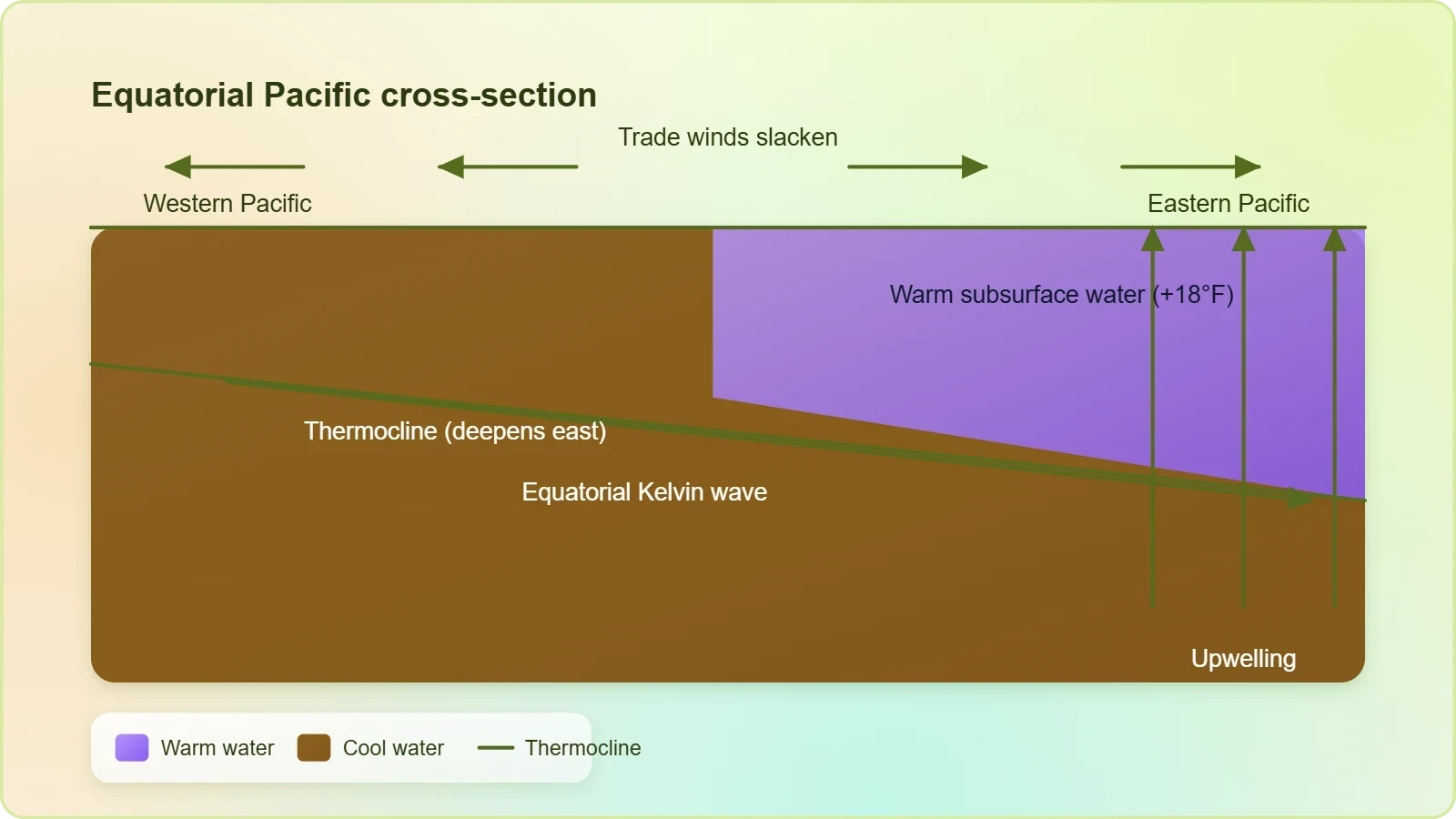
El Niño is fundamentally a disruption of the coupled ocean-atmosphere system that governs the tropical Pacific, and the current event illustrates that machinery with unusual clarity. Trade winds that normally pile warm water in the western Pacific have slackened, allowing the thermocline to flatten and the warm pool to migrate eastward. When that subsurface heat surfaces, it reorganizes atmospheric convection, shifting the primary rising branch of the Walker circulation away from Indonesia and toward the central Pacific. The result is a cascade of teleconnections that ripple through global weather patterns, influencing everything from North American storm tracks to rainfall across South America and Australia.
Subsurface Heat as a Leading Indicator
Forecasters pay close attention to subsurface temperature anomalies because they function as a reservoir that can sustain or amplify surface warming for months. The current readings, running up to 18 degrees Fahrenheit above average at depth, represent an extraordinary store of thermal energy that is already rising toward the surface. L'Heureux's description of these values as "pretty extraordinary" reflects how far outside the typical envelope they sit. Because subsurface heat precedes and feeds surface anomalies, it offers a forward-looking signal that the event may persist or even strengthen, giving scientists a window into the winter ahead.
The mechanics of that upward migration involve equatorial Kelvin waves, which transport warm water eastward along the thermocline before it upwells in the eastern Pacific. When the thermocline deepens in the east, cooler water from below no longer reaches the surface as readily, and the warm layer thickens. This process explains why subsurface anomalies often foreshadow surface developments by several months. For the current event, the combination of deep warm water and weakened trade winds suggests the thermal engine has ample fuel, though atmospheric feedbacks ultimately determine how much of that heat translates into surface warming.
Why the East Pacific Location Matters
The distinction between east-based and central Pacific El Niños has become a central preoccupation in climate research because the two flavors produce divergent weather outcomes. When the warmest water sits in the eastern equatorial Pacific, as Karnauskas observed, the atmospheric response tends to favor a strengthened subtropical jet and enhanced moisture transport toward California and the southwestern United States. Central Pacific events, by contrast, shift convection westward and often yield different precipitation signatures. The "textbook" east-based structure of this event therefore tilts the odds toward certain winter outcomes, though researchers emphasize that the science remains an active area of inquiry rather than settled doctrine.
Karnauskas's characterization carries practical weight for water managers, agricultural planners, and emergency agencies across the American West. California's precipitation fortunes hinge on atmospheric river activity, and east-based El Niños have historically been associated with wetter winters there, though the relationship is probabilistic rather than deterministic. Some studies support the link, while others caution that the sample of strong events is small and confounded by other factors. The current event offers researchers a valuable natural experiment, arriving with unusually well-documented subsurface precursors and a clear east-based geometry that can be compared against historical analogues.
The Rapid Transition from La Niña to El Niño
The most striking feature of this event may be its tempo. Climate records typically show El Niño developing over a year or more, with trade wind anomalies gradually accumulating and the thermocline responding in kind. The 2026 transition compressed that sequence dramatically: La Niña conditions prevailed at the start of the year, and by July the Pacific had warmed to a level matched only by the 1997–1998 super event. Lindsey Long's observation that monthly sea surface temperatures ranked second in the modern record underscores how far the system traveled in a short span. Such rapid reversals are not unprecedented, but they are uncommon enough to command scientific attention.
Historical Precedents for Fast Onset
Researchers have documented several past strong El Niño events that followed similarly abrupt transitions, and those analogues offer clues about what may unfold. The 1997–1998 event, often cited as the modern benchmark, also developed with unusual speed after a prolonged warm-pool buildup in the western Pacific. When the trade winds collapsed, the accumulated heat surged eastward in a series of Kelvin waves, producing rapid surface warming. The current event appears to share elements of that script, though each episode carries its own idiosyncrasies. Scientists are careful to note that historical similarity does not guarantee analogous outcomes, since background climate conditions and stochastic atmospheric variability differ from event to event.
The speed of onset also complicates forecasting, because the atmospheric system has less time to adjust to the changing ocean boundary conditions. Teleconnections that normally establish themselves over months may lag behind the oceanic signal, creating windows of uncertainty in seasonal outlooks. Forecasters must weigh the strong oceanic forcing against the possibility that atmospheric circulation patterns have not yet fully reorganized. This tension between a powerful thermal driver and a still-adapting atmosphere is one reason NOAA's messaging emphasizes probabilities rather than certainties, and why L'Heureux has cautioned that record intensity alone does not dictate specific regional impacts.
Implications for Seasonal Forecast Confidence
Seasonal forecasting is an exercise in managing uncertainty, and rapid-onset events strain the models that underpin it. When ocean conditions shift faster than the historical calibration of forecast systems assumes, the statistical relationships embedded in those models may understate or misplace the eventual response. Forecasters therefore lean on multiple lines of evidence: dynamical model ensembles, statistical analogues, and real-time monitoring of atmospheric indicators such as the Southern Oscillation Index and outgoing longwave radiation. The convergence or divergence of these signals shapes confidence levels in winter outlooks, and the current event's unusual profile makes that convergence particularly worth watching in the weeks ahead.
For decision-makers in agriculture, water resources, and disaster preparedness, the practical takeaway is that planning should accommodate a range of outcomes rather than a single forecast. A strong east-based El Niño tilts the odds toward wetter conditions in parts of California and the Southwest, but it does not eliminate the possibility of dry spells or shift the entire storm track uniformly. Prudent risk management means preparing for the more likely scenario while retaining flexibility for alternatives. The scientific community's candor about these limits reflects a mature understanding that seasonal prediction, however sophisticated, remains a probabilistic enterprise rather than a deterministic one.
We Also Published
Consequences for the Atlantic Hurricane Season
El Niño's influence extends far beyond the Pacific, and one of its most consequential remote effects is the suppression of Atlantic hurricane activity. During El Niño years, enhanced convection over the central Pacific drives upper-level wind anomalies that reach across the tropical Atlantic, increasing vertical wind shear. Strong shear tears at developing tropical cyclones, disrupting their vertical structure and limiting intensification. The 2026 Atlantic season appears to have felt this effect, with forecasters who had initially anticipated a somewhat active but below-average season observing muted storm development as the Pacific warmed. The timing of the El Niño onset likely mattered, arriving early enough to shape the peak months of the season.
The Wind Shear Mechanism
The physical chain linking Pacific warmth to Atlantic shear runs through the Walker circulation and its associated upper-level outflow. When convection shifts eastward over the central Pacific, the resulting upper-level divergence generates anomalous westerly winds aloft over the Caribbean and tropical Atlantic. These winds oppose the easterly flow at lower levels, creating the vertical wind differential known as shear. Tropical cyclones require a vertically coherent vortex to concentrate their energy, and shear undermines that coherence by tilting and ventilating the storm core. The stronger the Pacific forcing, the more pronounced this shear becomes, though other factors such as Saharan dust and sea surface temperatures also modulate seasonal outcomes.
Forecasters had expected a moderately active Atlantic season, and the observed suppression illustrates how Pacific conditions can override Atlantic-based signals. This interplay between basins is a recurring theme in seasonal forecasting, where competing influences must be weighed against one another. The 2026 season's outcome will provide valuable data for researchers refining the statistical relationships between El Niño strength and Atlantic storm counts. It also serves as a reminder that hurricane risk is not solely a function of Atlantic warmth; the broader tropical climate system, with its interconnected circulations, shapes outcomes in ways that require global rather than regional analysis.
Coastal Risk and Preparedness Lessons
A quieter Atlantic season offers welcome relief to coastal communities, but it carries a subtle risk of complacency. Suppressed seasons can mask underlying vulnerability, encouraging residents to defer preparations that remain essential regardless of seasonal forecasts. Emergency managers emphasize that a below-average season still produces dangerous storms, and the absence of major landfalls is a matter of luck rather than safety. The 2026 season's muted activity should therefore be read as a reprieve rather than a reprieve from responsibility. Preparedness investments made during quiet years pay dividends when active years inevitably return, and the institutional memory of recent destructive seasons remains a powerful argument for sustained vigilance.
Insurance markets and reinsurance pricing also respond to seasonal forecasts, and a suppressed Atlantic season may ease some pressure on coastal property markets. However, actuaries caution against reading too much into a single season, since catastrophe risk is priced over multi-decade horizons. The Pacific's influence on Atlantic activity is one variable among many, and climate change is altering the baseline against which seasonal variability plays out. Warmer ocean temperatures overall can offset some of El Niño's suppressive effect, creating conditions where fewer storms form but those that do may intensify rapidly. The interplay of these forces keeps risk assessment a dynamic and demanding discipline.
Winter Weather Outlook and Regional Uncertainty
As autumn gives way to winter, attention turns to how the Pacific warm pool will shape storm tracks across North America. Strong El Niño events have historically tilted the odds toward wetter-than-average winters along the US West Coast, particularly in California, where atmospheric rivers can deliver prodigious rainfall. The east-based geometry of the current event strengthens that signal in some studies, though researchers are quick to note that the relationship is statistical rather than ironclad. NOAA's L'Heureux has emphasized that record or near-record intensity does not guarantee specific impacts, a caution that reflects both scientific humility and the genuine complexity of atmospheric response.
California Precipitation Prospects
California's water supply hinges on a handful of atmospheric river events each winter, and El Niño can modulate their frequency and intensity. During east-based events, the subtropical jet tends to extend farther east across the Pacific, steering moisture-laden storms toward the West Coast. Some studies have found a robust correlation between east-based El Niño and enhanced California precipitation, though the sample size of strong events is limited. The 2026 event's textbook structure makes it a particularly interesting test case, and water managers will be watching reservoir inflows and snowpack accumulation closely as the winter unfolds. Even a favorable tilt, however, does not preclude dry spells or guarantee drought relief.
The stakes are considerable for a state that has oscillated between drought and deluge in recent years. Wetter winters can replenish reservoirs and aquifers, but they can also bring flooding, mudslides, and infrastructure strain, particularly in areas scarred by wildfire. Emergency planners must prepare for both possibilities, since El Niño tilts probabilities without dictating outcomes. The scientific literature on east-based events offers guidance but not certainty, and the interplay with other climate patterns such as the Madden-Julian Oscillation can modulate outcomes on subseasonal timescales. California's water managers have learned to plan for variability rather than averages, and this winter will test that adaptive capacity.
Broader North American Impacts
Beyond California, El Niño reshapes winter weather across the continent in ways that affect agriculture, energy demand, and transportation. The southern tier of the United States often experiences cooler and wetter conditions, while the northern tier tends toward milder temperatures. These patterns influence heating demand, crop yields, and snow removal budgets across a vast geography. The current event's strength suggests these typical teleconnections may be pronounced, though regional details depend on the precise evolution of the jet stream. Forecasters will monitor the Arctic Oscillation and other modes of variability that can amplify or dampen El Niño's influence, since the final outcome reflects a superposition of multiple climate signals.
For the energy sector, milder northern winters can reduce natural gas demand for heating, while wetter southern conditions may affect hydropower generation and agricultural output. The insurance industry watches these patterns closely, since winter storm losses can be substantial. Transportation agencies in snowy regions plan snow removal budgets based on seasonal outlooks, and a strong El Niño can shift those expectations. The cascade of economic consequences from a Pacific temperature anomaly illustrates how deeply interconnected the climate system is with human activity, and why investments in seasonal forecasting and climate monitoring yield returns across multiple sectors of the economy.
Reading the Science: What Forecasters Know and Don't
The public conversation around El Niño often gravitates toward superlatives, but the scientific reality is more nuanced. Researchers have made substantial progress in understanding the physics of ocean-atmosphere coupling, yet significant uncertainties remain about how specific events will translate into regional weather. The current event's extraordinary subsurface warmth and rapid onset place it in rare company, but the historical record offers only a handful of comparable analogues. Each event unfolds against a unique backdrop of background climate conditions, making precise prediction a formidable challenge. The scientific community's measured language reflects genuine uncertainty rather than evasiveness.
Model Limitations and Ensemble Approaches
Modern seasonal forecasting relies on ensembles of dynamical models, each run with slightly perturbed initial conditions to sample the range of plausible outcomes. When the ensemble members agree, confidence rises; when they diverge, forecasters communicate wider uncertainty. The 2026 event's rapid development may challenge models calibrated on slower transitions, potentially widening the spread of projections. Researchers are actively studying how forecast systems perform during rapid-onset events, using the current episode as a natural experiment. The resulting insights will inform future model development and improve the reliability of seasonal outlooks for years to come.
Statistical models complement dynamical ones by drawing on historical relationships between Pacific temperatures and regional outcomes. These approaches are powerful when the current event resembles past ones, but they struggle when conditions fall outside the historical envelope. The combination of record subsurface warmth and rapid onset may push the current event into territory where statistical relationships are less reliable. Forecasters therefore triangulate across methods, weighing dynamical and statistical evidence alongside real-time observations. This pluralistic approach reflects the maturity of the field, which has learned to embrace uncertainty rather than pretend it away.
Communicating Uncertainty to the Public
Translating probabilistic forecasts into public communication is a persistent challenge, because audiences often crave certainty that the science cannot provide. Phrases like "elevated odds" and "favored outcomes" are precise but can be misread as hedging. Meteorologists and climate scientists have worked to develop clearer messaging that conveys both the signal and its limits. The current event, with its dramatic numbers and rapid development, presents a particular communication test: how to convey the significance of extraordinary ocean temperatures without overpromising specific impacts. NOAA's approach, emphasizing that intensity does not guarantee outcomes, represents a deliberate effort to calibrate public expectations.
Effective communication also matters for decision-makers who allocate resources based on forecasts. Water agencies, emergency managers, and agricultural planners need to understand not just the most likely scenario but the range of plausible alternatives. Forecast products that quantify uncertainty, such as probability distributions and scenario analyses, serve these users better than single-value predictions. The scientific community's growing emphasis on decision-relevant forecast products reflects a broader shift toward user-centered climate services. As events like the 2026 El Niño become more common in a warming climate, the demand for clear, honest, and actionable information will only intensify.
Climate Context and the Road Ahead
Placing the 2026 El Niño in a longer climate context reveals both continuity and change. El Niño and La Niña have cycled through the Pacific for millennia, but the backdrop against which they now unfold is warmer than at any point in the instrumental record. This raises important questions about whether the intensity and behavior of El Niño events are shifting in response to anthropogenic warming. Some research suggests that extreme El Niño events may become more frequent as the tropical Pacific warms, though the science remains unsettled. The current event, with its record-adjacent warmth and rapid onset, offers a data point that researchers will scrutinize for years.
El Niño in a Warming Climate
The relationship between climate change and El Niño is one of the most actively debated topics in climate science. Warmer background ocean temperatures can amplify the thermal anomalies associated with El Niño, potentially pushing events into unprecedented territory. At the same time, changes in trade wind strength and ocean stratification could alter the dynamics that generate El Niño in the first place. The 2026 event's extraordinary subsurface warmth may reflect both natural variability and the influence of a warming ocean, though disentangling the two requires careful attribution analysis. Researchers will compare this event against climate model simulations to assess how much of its intensity is attributable to long-term warming.
The practical implications of this research extend to infrastructure planning, water management, and disaster preparedness. If extreme El Niño events become more common, coastal communities, agricultural regions, and water systems will need to adapt to more frequent swings between wet and dry extremes. The current event serves as both a warning and a learning opportunity, demonstrating the kinds of conditions that may become more typical in coming decades. Scientists emphasize that adaptation planning should account for the full range of plausible futures, including both more frequent extremes and the possibility that El Niño behavior could shift in unexpected ways.
Monitoring and Preparedness Priorities
Robust monitoring systems are the foundation of effective early warning, and the current event demonstrates their value. The TAO/TRITON array of moored buoys, satellite observations, and Argo floats provide the data streams that underpin El Niño forecasts. Investments in these systems pay dividends by enabling earlier and more accurate warnings, giving communities time to prepare. The extraordinary subsurface readings that L'Heureux described were only possible because of sustained observational infrastructure. As climate variability intensifies, maintaining and expanding these networks becomes an even higher priority for governments and research institutions worldwide.
Preparedness also requires translating scientific information into actionable guidance for the public and for decision-makers across sectors. The 2026 El Niño will test how well the existing warning system functions, from NOAA's seasonal outlooks to state-level water management decisions to individual household preparations. Lessons learned from this event will inform improvements in communication, coordination, and response. The scientific community's willingness to acknowledge uncertainty while providing the best available guidance is a model for how complex environmental risks should be communicated. As the winter unfolds, the world will watch how this extraordinary Pacific warmth reshapes weather patterns across the globe.
From our network :
- Forbidden Matrix Patterns and Visible Lattice Points: A Geometric DictionaryExplore how multidimensional 0–1 matrices encode geometric truths, linking forbidden patterns to visible lattice points and hypergraph theory, with applications in combinatorics and computational geometry.
- CISA’s Ten-Advisory Wave: Why Generic Patching Fails in OT and How to Build Product-Specific PlaybooksCISA released ten ICS advisories in one week, exposing critical infrastructure risks. Generic patching fails in OT. Learn to build product-specific remediation playbooks.
- Committed Mediterranean Precipitation Decline: Why Emissions Cuts Alone Cannot Restore Winter RainsNew NOAA research reveals that Mediterranean winter rains may decline irreversibly even with emissions cuts. Explore the science of committed climate change and regional impacts.
- University Language Proficiency Exams: Why Institutional Tests Demand Different Preparation Than IELTS and TOEFLDiscover why university-specific language proficiency examinations differ fundamentally from IELTS and TOEFL, and learn strategic preparation approaches for institutional assessment success.
- Live Online English Classes for Kids: Do They Actually Reduce Anxiety?A ten-week study reveals that synchronous online English classes can significantly reduce child language anxiety while improving listening and reading skills. Discover what makes these programs effective and how parents can select the right one.
- The Final Descent: How ESA Retired the Legendary Cluster Constellation After 24 Years of Space Weather ScienceAfter 24 years mapping Earth’s magnetosphere, ESA’s Cluster mission concluded with a precisely controlled reentry over the South Pacific. This analysis explores the scientific legacy, engineering decisions, and debris mitigation principles behind one of space exploration’s most responsible retirements.
- How AI Agents Will Change the Way We Manage Personal FinancesExplore how AI agents are transforming personal finance through automated budgeting, bill payment, and investment management, while examining the critical security protocols and governance frameworks required for safe deployment.
- The Hidden Cost of AI Convenience: Why Over-Permissioned Agents Are a Security Time BombDiscover why AI agents with excessive permissions create dangerous single points of failure, and learn how implementing least privilege principles can protect your organization from exploitation.
- Mobile Learning and VR in English: What Global Evidence Reveals About Effective Language TechnologyA systematic review across 14 countries reveals which language-learning technologies genuinely work. Mobile learning, AI, and VR show measurable benefits when pedagogically integrated. This evidence-based guide helps educators and learners select technology that delivers real return on investment.
RESOURCES
- El Nino forms, expected to strengthen, say NOAA forecastersnoaa.govJun 11, 2026 ... During a typical El Nino winter, the jet stream over the north Pacific Ocean tends to shift southward, bringing the…
- Governor Newsom proclaims state of emergency to bolster ...gov.ca.govSep 21, 2026 ... SACRAMENTO – As a historic El Niño storm season develops, Governor ... El Niño's anticipated impacts, like strong storms and…
- Understanding El Niño & ENSO - NOAAnoaa.govThis ocean–atmosphere coupling impacts the position of the Pacific jet stream and influences weather and climate patterns globally. A map of the U.S. and…
- WMO: Prepare for El Niñowmo.intJun 2, 2026 ... El Niño is characterized by a warming of ocean surface temperatures in the central and eastern Equatorial Pacific. ... hurricane…
- El Niño Looms Large Over This Hurricane Seasonclimate.ncsu.eduMay 21, 2026 ... But hurricanes do tend to bring amplified impacts, including high winds and storm ... Winter Outlook 2026-27: All Eyes on…
- El Niño set to become very strong, raising risks of extreme weather ...wmo.intSep 3, 2026 ... ... temperature and rainfall for the season September-November 2026. The ... temperatures in the central and eastern Equatorial Pacific. It ...
- Heads up! 2026 is officially an El Niño year and could be one of the ...facebook.comJun 13, 2026 ... Since I expect a very busy hurricane season in the Eastern Pacific and a weak cold water shield, I see…
- What are El Nino and La Nina? - NOAA's National Ocean Serviceoceanservice.noaa.govSep 23, 2026 ... El Niño and La Niña are climate patterns in the Pacific Ocean that can affect weather worldwide. ... Warmer or…
- El Niño and its Effect on the Southeast U.S. - National Weather Serviceweather.govEl Niño generally brings above average precipitation to Florida during Fall-Winter-Spring...reduced risk of wildfires...higher risk of flooding. Increased ...
- Impacts of El Niño and La Niña on the hurricane season - Climateclimate.govMay 30, 2014 ... El Niño typically favors stronger hurricane activity in the central and eastern Pacific basins, and suppresses it in the Atlantic…
- Regional Super El Niño Impacts: Southwest U.S. - USGS.govusgs.govAn active Pacific hurricane season is more likely during El Niño. Warmer ... Comparison of Seasonal Forecast Models for 2026–2027 Winter Weather Conditions in…
- El Niño is coming - University of Miami Newsnews.miami.eduApr 8, 2026 ... ... temperatures in the equatorial Pacific Ocean, could impact the upcoming Atlantic hurricane season. El Nino 2026. NOAA's GOES-16 satellite ...
- El Niño is strengthening: Here's what it means for the US - ABC7 Newsabc7news.comJul 14, 2026 ... ... hurricane season and global temperatures ... 2026 Atlantic hurricane season with above average activity likely in the eastern Pacific.
- Climate Prediction Center: ENSO Diagnostic Discussion - NOAAcpc.ncep.noaa.gov6 days ago ... Compared to last month, El Niño strengthened as sea surface temperature ... east-central equatorial Pacific. Convection and rainfall ...
- El Niño in the Northwest: What Can We Expect? | USDA Climate Hubsclimatehubs.usda.govIt is marked by warmer-than-average sea surface temperatures in the central and eastern Pacific Ocean near the equator. On average, El Niño occurs every…
- 01
- 02
- 03
- 04
- 05
- 06
- 07
- 08
0 Comments